Excavations 2009
We obtained planning permission on 12 May 2008 to renovate an old barn into Rudchester Barn as an annexe to Rudchester Manor. The permission required an archaeological watching brief which was undertaken by AOC Archaeology Group, part of which is available on the Archaeology Data Service website.
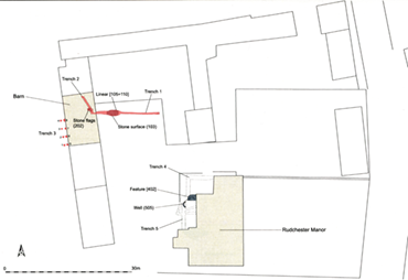
Three trenches were dug as part of these preparatory works for the Barn:
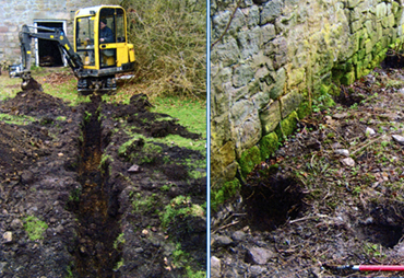
1) The excavation of a sewer pipe trench across the courtyard
2) Excavations and ground reduction within the barn
3) The excavation of postholes to the rear (West) of the barn
Rudchester Barn Excavations 2009
Click here for a high resolution scan in a new window:
Trenches 1 & 3
Click here for a higher resolution photograph in a new window:
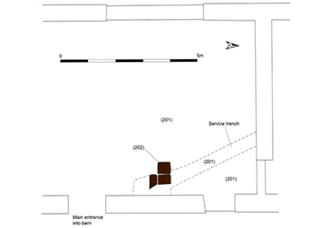
Trench 2
Click here for a high resolution scan in a new window:
Excavations around Rudchester Barn revealed significant post-medieval and limited medieval activity. In Trench 1, natural subsoil was exposed beneath a buried soil horizon, which may represent a 12th century activity layer. A compacted stone surface was found at the western end of the trench, truncated by later disturbance and possibly representing a yard or path surface. A linear ditch to the east contained Roman pottery and a sherd of 12th–13th century pottery, suggesting backfilling during the medieval period, though interpretation remains tentative due to the small excavation area and poor environmental preservation.
The barn’s internal floor was revealed during removal of the existing surface in Trench 2, exposing a heavily truncated earlier stone-flagged floor laid over post-medieval levelling material. Several large, re-used Roman masonry blocks were also recovered, likely sourced from nearby fort structures.
To the rear of the barn (Trench 3), 8 postholes were excavated. The southern group contained re-deposited topsoil with angular stones, while the northern group revealed a possible stone-flagged surface associated with the 19th century barn extension. This surface, which abutted the barn foundation, likely belonged to an internal floor of the barn’s now-demolished western extension, recorded on early OS maps. Parts of the rear area may have been artificially raised.